
Top 5 Can’t Miss
- Hike to the “top of Texas” on the Guadalupe Peak Trail.
- Enjoy some of the darkest skies in the state—camp out under the Milky Way and gaze up at the glittering expanse of stars.
- Catch vibrant fall foliage in McKittrick Canyon.
- Visit the fern-covered Smith Spring, a sparkling ribbon of water in the otherwise arid desert.
- Learn about the people who lived and worked in this extreme landscape at the Frijole Ranch Museum.
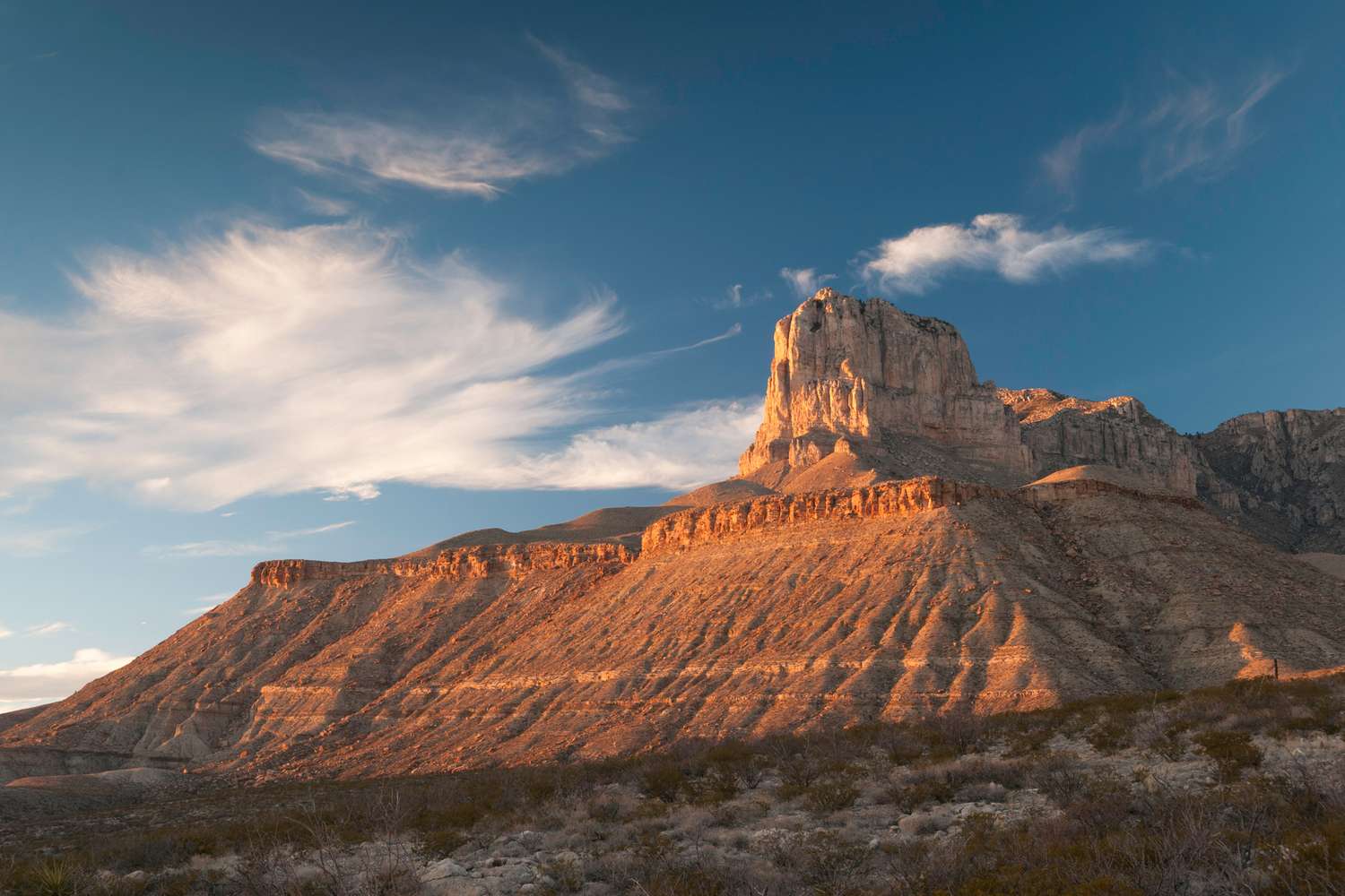
From the summit of the 8,751-foot Guadalupe Peak, sweeping vistas of desert stretch seemingly endlessly until they fade into the hazy Texas sky.
To the southwest, a giant fossil reef called El Capitan juts out, cutting a stark shape against the gentle foothills beyond. Texas is more likely to be known for its wide-open spaces than its mountains, but at Guadalupe Mountains National Park, home to the tallest mountain in Texas, visitors can experience all three.
97 percent of the 86,416-acre park, located along Texas’ northern border with New Mexico, is managed as a wilderness, making it a precious resource in a state that is more than 95 percent privately owned.
“In the state of Texas, the opportunity to hike and lose yourself in the natural environment—and I mean not physically lose yourself, but to be able to mentally experience the sights, the sounds, the smells, the natural environment all around you that’s unaltered—it’s magical,” says Theresa Moore, the park’s public information officer.
The Guadalupe Mountains are the world’s most extensive exposed fossil reef. During the Permian Period, 251 to 299 million years ago, a shallow sea covered much of West Texas and southeastern New Mexico. About 80 million years ago, when the sea had long since dried up, a tectonic event brought part of the reef up out of the ground, forming the Guadalupe Mountains. Take a closer look at the rocks beneath your feet—here, they often prove to be fossilized coral or other marine life. (You’ll likely see some oil rigs on your drive in—they’re on the hunt for another byproduct of the long-lost Permian sea).
In more recent history, the park’s natural springs—rare sources of water in the desert—have attracted people to the area for thousands of years. From the Mescalero Apaches who harvested bighorn sheep and elk here, to American pioneers who dammed some of the springs and established a ranch, to the mail carriers who would stop here in the 1850s, this land has a deep history. “The majority of people come to hike Guadalupe Peak,” says Moore. “They want to reach the top of Texas. It’s on their bucket list, and that is awesome. But the surprising thing is the cultural side of the park.”
The park is a biodiversity haven, too. From arid gypsum dunes to verdant springs and seeps, desert foothills to the sheltered, green high country of “the bowl,” the park’s varied terrain allows many species of animal and plant life to thrive here. “If you’re going to hike McKittrick Canyon, you’re starting in a desert,” says Moore, referring to one of the park’s trails that cuts through the lowlands into the mountain range. “There are cacti, and everything has thorns. It’s beautiful, Chihuahuan desert. But then, as you start to hike up, you notice—and it should catch you by surprise—ponderosa pine trees, maple trees, pinyon pine, alligator Juniper, the Texas madrone.”
The park is the 12th least visited national park in the U.S., so if you’re looking for peace and quiet, this is the place to be. “Guadalupe Mountains has trails where you can stand there and not see another human, and that’s pretty special, in a national park, to be able to have that experience,” says Moore.
Here’s what you need to know before planning a trip to Guadalupe Mountains National Park.
Know Before You Go
Dennis Macdonald/Getty Images
An entrance pass for Guadalupe Mountains costs $10, or you can get in with your America the Beautiful Pass, the National Parks and Federal Recreational Lands’ annual pass. Pay at the Pine Springs Visitor Center (open 8 a.m. to 4 p.m.) or at any of the self-pay stations located at trailheads.
However, before you make a trip to Guadalupe Mountains National Park, make sure you come into the park with a full tank of gas. “When you see a sign that says, ‘Next gas 35 miles,’ we’re not joking,” says Moore.
There is no gas within the park, and the closest gas stations are located in Whites City, New Mexico (35 miles northeast); Van Horn, Texas (60 miles south); and El Paso, Texas (120 miles west). And since the park’s location is fairly remote, you may have trouble getting cell coverage—so be prepared.
Bringing enough water on your hikes is essential, too. The dry desert air and intense sun mean you’ll dehydrate faster than you would normally. Park staff recommend packing at least one gallon of water per person per day.
Lastly, keeping time in the park can be confusing since it straddles two time zones. “The park is on mountain time, but your phones will be reading Central Time,” says Moore.
Best Time to Visit
Tim Speer/Getty Images
The best months to visit Guadalupe Mountains are in April and May, before it gets too hot, and in October and November, when temperatures have cooled and visitors can appreciate the fall colors (a Texas rarity!) in McKittrick Canyon. While the park is open year-round, winter weather can be unpredictable, and there are sometimes winds of more than 80 miles per hour. Summer temperatures can reach up to the high 80s, however, visitors will experience hotter temperatures at lower elevations and cooler conditions in the mountains. Regardless of when you visit, make sure to bring plenty of water, sunscreen, and a pair of good hiking shoes.
How to Get There
Mark C Stevens/Getty Images
You’ll definitely need a car to get around the area—there’s no public transportation or shuttle available in the park. And no matter which airport you choose to fly into, you’re in for a drive. The closest airport is Cavern City Air Terminal (CNM) near Carlsbad, New Mexico, which is 46 miles away. However, Cavern City is a fairly small airfield, and you may have limited flight options. The closest major airports are Midland International Air & Space Port (MAF) in Midland, Texas (about 182 miles and three hours away) or El Paso International Airport (ELP) in El Paso, Texas, which is 103 miles and about two hours away.
The main entrance of the park is located along U.S. Route 62, about 110 miles west of El Paso. You’ll find the Pine Springs Visitor Center here as well as a park store. There’s another smaller one, McKittrick Canyon Visitor Center, 10 miles down the road, which has outdoor interpretive signage and a video exhibit. “I call it an inside-out visitor center, because everything’s outside,” says Moore.
Because the park is mostly managed as a wilderness, no roads cut through its interior—the only way to see what’s beyond the mountains is to hike in. While most trails are accessible on the south side of the park along U.S. Route 62, there are a couple on the other ends of the park you can drive around to. On the far west side of the property, about an hour’s drive from the Pine Springs Visitor Center, the Salt Basin Dunes Trail showcases a different side of the desert. And on the far north edge of the park, a two-hour drive from the visitor center that loops up into New Mexico, visitors can hike into the secluded, forested wilderness of Dog Canyon.
Best Things to Do
RobertWaltman/Getty Images
Sit in on a ranger program.
Rangers at the Pine Springs Visitor Center hold daily programs. Join in to learn about the park’s fabulous reptiles, the constellations above, or the fascinating geologic history of the area.
Visit the Frijole Ranch History Museum.
In the late 1800s, settlers to the area established a working ranch near some of the park’s springs. The Frijole Ranch History Museum is a volunteer-run museum with limited hours. Visit to learn about the area’s storied past, from the Native Americans who lived on the land to the early settlers and ranchers who ran the operation.
Enjoy the night sky.
With no cities nearby and very minimal light pollution, Guadalupe Mountains National Park has prime stargazing opportunities. Make time to lie outside in the cool desert night and appreciate the stunning Milky Way views and the constellations above. The rangers sometimes host stargazing programs, too.
Watch for wildlife.
The park’s variety of ecosystems make it a great home for hundreds of wildlife species. Keep an eye out for Texas horned lizards sunning themselves on rocks, rainbow-hued Eastern collared lizards darting across the trail, and mule deer and javelinas out foraging in the early morning while the temperatures are cool. The park is also home to 289 species of birds.
See the sand dunes.
On the west side of the park, you can find a totally different desert landscape at Salt Basin Dunes. When it rains, salts and sediments drain off the Guadalupe Mountains to the flat lands to the west, creating barren salt flats. As they dry out, wind carries salt and gypsum back to the base of the mountains, creating a landscape of soft white dunes that rise 100 feet above the desert floor.
Learn about the Butterfield Stage Coach Route.
In 1858, transportation entrepreneur John Butterfield established the Butterfield Overland Stage Coach Route, which carried mail and passengers from San Francisco to St. Louis and connected settlers in the American West more directly with their eastern counterparts (previously, all mail from the West took a circuitous steamship route through Panama to reach the East Coast). The Butterfield route was short-lived and ended with the start of the Civil War, but traces of it remain in Guadalupe Mountains National Park along the Pinery Trail, which leads to the ruins of a stop on the route, the old Pinery Station.
Best Hikes
kellyvandellen/Getty Images
Guadalupe Peak Trail
This hike is worth it—but be prepared. The trek to the top of Texas is a strenuous, 8.4-mile round trip with 3,000 feet of elevation gain. The first two miles are the hardest, composed of rocky stairs and switchbacks winding steeply up the side of the mountain. The next two miles are still uphill, but the grade is gentler. As you near the summit, you’ll see expansive views of the foothills nearby and farmlands in the distance, and close-ups of the majestic Capitan Reef. Bring at least a gallon of water, as well as snacks. “Don’t forget, when you get to the top, you’re only halfway done,” says Moore. “You’ve got to get back down!”
Hunter Peak
If you seek a more solitary hiking experience, Hunter Peak also has stunning views of Guadalupe Peak without the crowds. This 8.7-mile strenuous loop trail starts at the Pine Springs trailhead. Ascend the peak via the Bear Canyon trail (the steeper route) and return on the Tejas trail, which winds through the mountains with views of Guadalupe Peak and Devil’s Hall.
The Pinery
This accessible trail begins right at the Pine Springs Visitor Center and is just .75 miles long. “It’s lovely for all levels of hikers,” says Moore. The trail leads from the visitor center to the ruins of the Butterfield Overland Stage Stop, part of the mail route that ran from San Francisco to St. Louis in the mid-1800s, carrying mail and passengers across wild, western terrain.
Smith and Manzanita Spring Loop
This moderate 2.3-mile loop passes by both Smith Spring and Manzanita Spring. No swimming is allowed in the springs, but they’re perfect places to watch for wildlife, such as swallows swooping and dipping down for a drink. The Smith Spring loop does have some steep sections—for an easier hike, turn around at Manzanita Spring, just a short walk from the Frijole Ranch House.
McKittrick Canyon
Hike into McKittrick Canyon, a biodiverse and beautiful canyon known for its bigtooth maple trees, which turn brilliant colors in the fall. This trail has multiple attractions along the way, including Smith Cabin, a beautifully constructed house that looks out into the peaks; the Grotto, a cave filled with stalactites set into the cave wall that is a perfect stop for a picnic; and the Notch, a dramatic viewpoint where the McKittrick Canyon trail breaks through the ridge, with stunning views into the mountains beyond. Smith Cabin and the Grotto aren’t too strenuous of destinations, but getting to the Notch requires some hefty elevation gain.
Hike into the backcountry.
This wilderness park has 10 designated backcountry campgrounds with a total of 60 campsites. When planning a trip into the backcountry, water is the limiting factor on how long you can stay out. You’ll need to carry your own water for your entire trip, or make a plan to come down out of the backcountry to refill. Keep an eye on the weather—80-mile-per-hour winds can derail even the best-laid backpacking plan—and follow the park’s Leave No Trace policies. “Guadalupe Mountains is a fossilized sponge reef,” says Moore. “You’re not going to dig a cat hole in a fossilized sponge reef, so you have to be prepared. In order to get your backcountry permit issued to you, you have to show the rangers that you have one commercially produced human waste bag per person per night.”
Best Places to Stay
Pierdelune/Getty Images
Guadalupe Mountains has two campgrounds in the park with drive-in and walk-up spots available. The Pine Springs Campground, near the Pine Springs Visitor Center, is a great base camp if you’re planning to wake up early and hike Guadalupe Peak or do any of the other trails that start on this side of the park. The Dog Canyon Campground, on the far north side, is more secluded and remote. Both the campgrounds have flush toilets and running water, but neither has showers. The park does not have a lodge.
If the campgrounds are full, there are other RV parks and tent camping sites available in the area, including areas managed by the Bureau of Land Management such as Chosa Campground and Sunset Reef to the east. In the El Paso direction, you can camp at Hueco Tanks State Park & Historic Site. All are a fair drive from the park, so factor the distance into your travel plans. However, keep in mind that this is a fairly remote and sparsely populated part of both Texas and New Mexico, so be prepared to camp or drive to the nearest hotels in Carlsbad.
Places to Eat
Bring the food you need for your park stay—there are no restaurants or grocery stores within the park. The closest restaurants are in Carlsbad; Dell City, Texas; or Salt Flat, Texas, all of which are quite a drive. The park is often under a burn ban, so odds are you won’t be able to start a campfire, and you’ll need a camp stove. Sandwiches, hot dogs, pasta, or dehydrated meals are all good and simple options to cook at camp.
Make sure to pack plenty of nutritious snacks for your hikes, too—you can deplete calories and water faster than you think in the desert atmosphere. “You need to balance your diet and your intake, which means sweet and salty snacks, water, and electrolytes, because your body uses all of those things in different ways,” says Moore. “For sweet, I’m talking about fruit, and for salty, I’m talking about snacks like pretzels.”