
The good news is that you can now see the Nolichucky River sooner.
Since my first thru-hike of the Appalachian Trail in 2019, I’ve often thought about a cliff edge just above Erwin, Tenn., where the woods open to reveal the Nolichucky rushing from a gorge below. It is one of the AT’s pure postcard moments, a spot for which I even advocated in a recent Backpacker list of the iconic trail’s best 100 miles. More than once, I’ve seen it in my dreams.
Imagine my surprise, then, when I was dropping into Erwin along the AT in April and saw the wide brown river roaring through the valley floor nearly a half-mile ahead of that memorable vista. I shouldn’t have been shocked: In the last 140 miles since leaving Newfound Gap in Great Smoky Mountains National Park, I had seen hundreds of ways that Hurricane Helene had altered the trail. So many trees had fallen between where I stood and Erwin that less of them simply blocked the view. It was gorgeous, and it was sad.
But that was, after all, why I was there, to see how the trail had changed and was still changing after Helene. Before the flood waters even receded from Western North Carolina and Eastern Tennessee last fall, handwringing about the state of the trail in 2025 and the concomitant thru-hiking season were rampant. In the days after the catastrophe, I saw videos about how 500 miles of the trail were “obliterated” and read reports about how people intended to forego the AT in years to come.
In the months since, though, I had read very little about how the trail was doing and how passable it might be come spring. I lived for many years along the parts of the trail that Helene hit hardest and consider the area one of the country’s most wondrous expanses. So I asked the trail family I formed back in 2019 if they wanted to have a reunion, to walk 140 miles together and see how our old friend was faring. Two said yes—my wife, Tina, and our best friend, Ben. They joined me for the first three days, or until we reached Hot Springs, NC. I continued to Erwin solo, hoping to cross the Nolichucky and then go home.
So how is the AT right now? The short answer: As of April 2025, the AT in the Southern states is like a horrific multi-car pileup on the interstate that happened hours ago, just long enough that the wreckage has been moved to the side of the road to allow for cars to pass. The way is mostly clear, but the work is far from done. The very long answer follows, in the form of my trail diary for those six days.
Wednesday, April 2 (Northbound Mile 208.0–223.7)
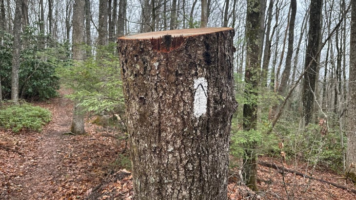
On a northbound trek of the AT, there’s no early landmark as critical as Newfound Gap, on the Tennessee border. When hikers reach it, they’ve arrived at their third state line, crossed the 200-mile mark, and passed the halfway point of one of the journey’s most arduous stretches through Great Smoky Mountains National Park. The weather can be terrible, the climbs severe, the resources limited. At Newfound Gap, folks often hitch northwest down U.S. 441, toward their first day off in Gatlinburg, Tenn. Some get lost in that tourist trap town and never return to trail.
Newfound Gap, then, felt like the natural start of our journey. After reading so much about reduced registrations for 2025 thru-hikes and consternation about whether or not the season would happen, I knew it would offer an instant read on the trail and how Helene had changed people’s plans. Would there be hikers there at all?
Before we could even park the car, we saw two of our kind—a tandem ripping open Priority Mail boxes of groceries atop a stonework fence and stuffing them into their already-swollen Hyperlite packs. Tourists stopping for pictures at the cloud-shrouded pass peppered them with questions about when they had started and when they might finish. Elsewhere, families posed with a sign that read, “Katahdin Maine 1972.0,” grinning like that was the silliest fact they’d ever seen. Yes, it seemed, thru-hiking season was on.
Our original itinerary involved an ambitious first day: 23 miles from Newfound Gap to Cosby Knob Shelter, with several thousand feet up and back down. But a park ranger had warned us against it: A five-mile expanse of fallen trees had slowed even the Ridgerunners, the trained professionals who shuttle along the trail to (sometimes overzealously) educate hikers about safety and Leave No Trace practices. “You should do a shorter day, 15 miles,” she said. “Spend the night at Tri-Corner Knob.” We agreed, deferring to the expert.
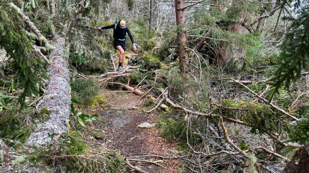
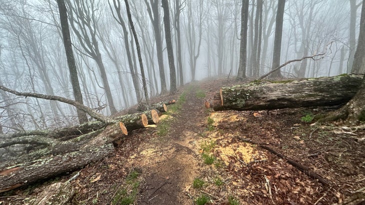
Perhaps it was the sheer adrenaline of three thru-hikers reuniting on the AT, but we soon knew we’d make our destination long before sundown. We raced through the first 10 miles, the air perfectly cool as the clouds closed in tight on the thin ridges the trail follows through the Smokies. The trees on trail first seemed like a nonissue, only slightly worse than any other year. There were a few blowdowns and freshly busted logs, their splinters cast across the trail like confetti. A few dead trees were suspended high above the trail, too—too high for a saw to get, a problem for the future. Maybe twice during those first 10 miles, we had to navigate somewhat tricky sets of blowdowns by stepping a few feet off trail, climbing down and then up to avoid some imposition. Still, if it slowed our pace, I didn’t notice.
It was the wind that finally made the peril clear. All day long, the breeze was intense, even blowing the usually surefooted Tina off a rock and to her knees. A half-dozen times, the wind gusted, and we noticed the earth heave from the trail, gaps of several inches sometimes appearing near our feet. Just below the catwalks we traversed, dozens of trees had been lifted out of the ground on all sides but one, a quarter of their root balls clinging on for dear arboreal life. As the wind roared and they swayed, you could watch their connection get evermore tenuous, like a piece of wire you repeatedly bend until it breaks. These were not our problem at the moment, but after a few severe summer thunderstorms, they would become a hazard for other hikers. It wasn’t hard to imagine the AT sliding off the face of, say, Raven or Katalsta ridges.
When we reached our shelter around 5 p.m., we again saw that thru-hiking season was indeed on. Tri-Corner Knob has two wide sleeping levels, meaning it can hold two-dozen hikers each night. The park prefers that thru-hikers stay in shelters to minimize impact and bear encounters. Folks had started claiming space for the night three hours earlier, hoping to escape the wind and threat of rain, and we were the last three to find some room that wasn’t just the ground. People traded tales of their first 200 miles like baby stories, proudly detailing the origins of their trail names or what gear they’d already sent home. Every now and again, someone would pass a video of a tree “yawning” in the day’s wind—that is, the roots separating from the soil. It was wild to see, maybe even funny, but I couldn’t help but wonder how much post-Helene damage had still yet to manifest itself, more than six months after the storm had passed.
Thursday, April 3 (Northbound Mile 223.7–244.1)
Boy, did I eat it.
When you leave the Smokies, you drop 3,500 feet in less than 7 miles, setting up a racecourse of sorts to Standing Bear Farm, a famously rowdy hostel with fridges full of cold beer for hikers who have just endured one of the AT’s great gauntlets. I love elevation changes in either direction, so I was locked in with the work of my quads as I began the great descent. And then, the sensation of my ankle twisting too far to the left jolted me from that flow, followed in short order by the thud of my body hitting the ground.
After more than 11,000 miles of hiking, I believe I’ve become one of the world’s great fallers, able to reorient myself just before impact. But this year, the AT—forever and always, a series of roots and rocks stretching out to trip you like the feet of a grade-school bully—feels different. Just yesterday, Tina, who once patrolled these woods as a park ranger, called it “junky.” The water moved so fast during Helene that the roots and rocks now feel more ubiquitous, making each step a negotiation. That’s compounded by shattered logs and fallen branches, debris too small (or too new) for any trail crew to fix. The trail simply seems more hazardous right now, and my ankle wanted a brief word—with me or with the trail, I can’t really say.
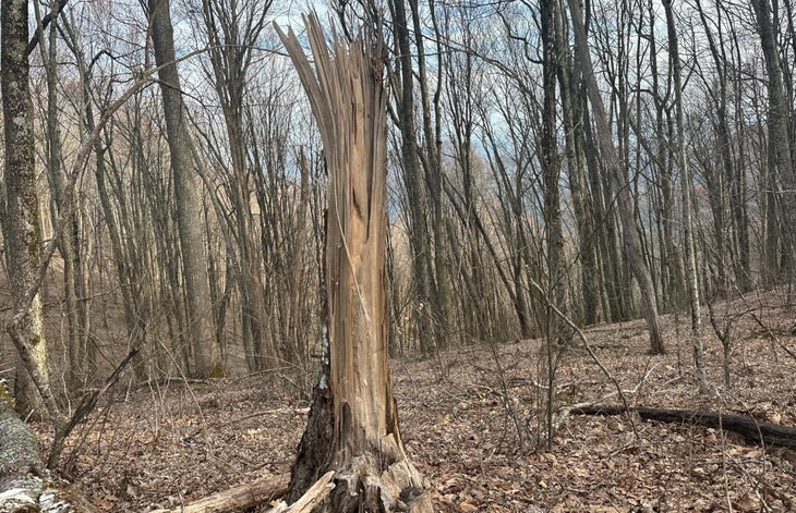
This morning, at least, the obstacles were a little more conspicuous. When we left the shelter, the clouds still cloaked the ridges, reducing visibility to a few hundred yards. But it didn’t take much to see the graveyards of trees that lined and occasionally still covered the AT. Only an hour into the day, we encountered a section where a hundred trees seemed to have fallen in a few hundred yards. Some leaned cattywampus across the trail, root ball and all, while others jutted shattered-end first onto the treadpath like swords. Climbing up, over, and through a thicket of damage, I caught a shin on several branches that had turned into natural shivs and spent the rest of the day trickling blood from my war wounds.
The ranger’s warning that this would slow us down, though, felt like a cautionary dose of old-fashioned AT fearmongering; this looked like fallout from meteorological microbursts, not the aftereffects of a sustained storm marching up the trail. The larger concern, once again, were the trees alongside the trail whose roots had largely been ripped from earth and now pointed down the mountain, ready to slide given the right squall. We made a sport of climbing into some of the city-bus-size craters those hulks had left behind.
Just before you begin the big drop that leads out of the Smokies, there is a final steep climb, like the last boss of the video game, from an intersection with the aptly named Low Gap Trail to the top of Mount Cammerer. It was the day’s most dangerously mangled expanse, with a dozen trees and innumerable branches crowding an already-thin bit of trail bordered by a rather precipitous drop. In 2,200 miles, the AT offers little in the way of rock-scrambling, but this felt like tree-scrambling, as I held onto branches while looking for places to plant my feet.
Just as I made it over the last hurdle, I spied a few blooming trilliums, three pale yellow flowers balanced above three brilliantly speckled leaves. A few miles later, I met a hiker from Indiana who, while taking a smoke break, spotted two morels, some of the first of the season. “These won’t be showing up at home for a few weeks,” he said, holding them in the palm of his hand. “It’s cool to be here. I’m going to try to go all the way.” He’d have more logs to climb than I did in 2019, but I assured him he could, then headed north again.
Friday, April 4 (Northbound Mile 244.1–267.8)
Soon after I turned 21, I participated in a collegiate bacchanalia called the Hillsborough Hike. It was an end-of-semester bar crawl for students at N.C. State, all stumbling from one end of our university’s main drag to another. I don’t remember how the night ended, but I do remember my phone waking me up sometime early the next afternoon. I was four hours late for my Saturday morning record-store shift, but I was there, green and groggy, 15 minutes later.
“Grayson! Well, how the hell are ya?” the store’s owner, Mike Phillips, said to me with a smirk later that afternoon. “I heard you were out a little late, son.” Twenty years later, the tone of voice he used that day still stings from memory.
Imagine my terror, then, when I heard the exact same sound a mile south of Max Patch, one of the most iconic balds in the Southern Appalachians and arguably the most beautiful place in all of North Carolina. “Grayson! Is that you?” a man in a tennis ball-colored shirt exclaimed from beneath the low brim of a baseball cap. “What the hell are you doing, son? Are you doing this shit again?”
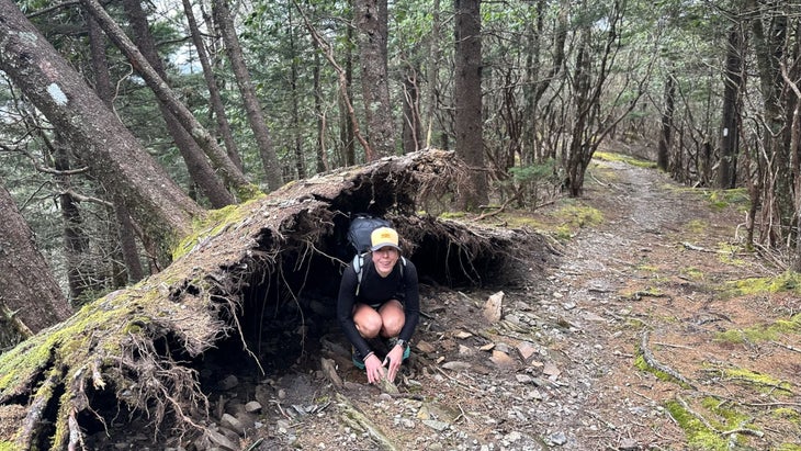
It was, indeed, Mike Phillips, who retired long ago from record-store life to manage triathlons and eventually join the Carolina Mountain Club, a largely volunteer-powered nonprofit that maintains 94 miles of the AT. I’d actually been thinking about Mike all morning, wondering if he was responsible for any of the sawdust I’d seen on trail. Not long after we slipped out of last night’s creekside campsite, I began to notice that the trees that had fallen on the trail had been cut so recently that the air still smelled like pine or poplar. Deep Gap had looked like a log graveyard, pines spilling across and above and alongside the trail in every direction. But the trees had been bullied aside enough to make room for whoever passed that way. Thanks, Mike and friends.
“It hasn’t been too bad,” said Ron, the first member of the Carolina Mountain Club I saw that morning, minutes before I encountered Mike. He’d put down his axe (labeled “RON”) to cut a little rut for runoff, hoping to prevent more topsoil from washing far below the trail. “It will get really bad when you get just south of Erwin, though. For every one tree left standing, you’ll see 20 that are down.”
All two-dozen members of the Carolina Mountain Club I saw in a 2-mile stretch were digging in the dirt. Mike was shoveling a rut like Ron. Two other men sat directly in the trail, cutting errant roots with oversized shears. That was a good sign, as Mike told me: “We just finished clearing our 94 miles of trail of trees. There were a lot,” he told me. Now it was time to tend to the trail itself, to manicure and maintain it like they would do every year.
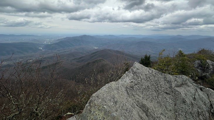
Our trio rendezvoused on Max Patch in time for lunch, the bald rimmed perfectly by stratus clouds in every direction. As we ate, families crisscrossed the mountaintop, easily accessible from a parking lot a mile below, while two young lovers made out on a picnic blanket. A string of thru-hikers said hello as they ambled past. And when we finally left, we ran into four men in their early 30s—all wearing all-camouflage everything, like they’d just raided an Army surplus store—who were a day away from finishing their first section of the AT. “We’ve loved it,” one of them said. “I’ve never done anything like this.”
We made camp that night in a grove of rhododendron bushes, having climbed 6,000 feet and descended 6,000 feet in 23 miles. The sun had set long before we sat down to eat in a semicircle amongst our tents. It struck us how normal our day had seemed, how much of it mirrored what we’d done on our first AT thru-hike. In fact, the whole day—from the trail crew tending to the dirt to the section hikers who seemed so supercharged by their new hobby, from our big miles to the long lunch in the sun—felt like it was trending toward normalcy, a welcome commodity on the AT in 2025.
Except seeing Mike. That was weird.
Saturday, April 5 (Northbound Mile 267.8–281.1)
A decade ago, Bluff Mountain Outfitters turned me into an AT hiker. It was June 2014, my first wedding anniversary. I’d started running to shed pounds for the ceremony and accidentally become obsessed with endurance. The idea of climbing mountains had become a long-distance daydream. So when Tina and I found ourselves in a remote cabin near Hot Springs, NC, one of the few towns the trail bisects, we had to get on the AT, on top of its old mountains. On our last day there, we climbed into a dirty van outside of Bluff Mountain Outfitters for a nauseating, hairpin shuttle to the top of Max Patch, then hiked 23 miles back to town. It felt like climbing K2. Four years later, we moved to Hot Springs; a year after that, we thru-hiked the AT.
It felt like a personal tragedy, then, seeing Bluff Mountain Outfitters on the national news, its rugged old brick frame ripped open by the rise and rush of Spring Creek, just feet away. It also made me worry for budding thru-hikers, since it’s an essential depot for supplies and intel from Wayne Crosby, who landed in Hot Springs after bailing on his own AT trek decades ago. How would newbies fare without him?
Turns out, they wouldn’t. After a gargantuan breakfast at the steadfast Smoky Mountain Diner, which rode out the storm like biscuits atop a raft of gravy, I was shocked to see the Bluff Mountain Outfitters insignia atop the old library building. I was more surprised to see how fresh and inviting it was inside, the cramped but lovable old store transformed into an airy space chockablock with more shoes and hiking food than I remembered at the former location. Crosby showed me how little bits of the old building, likely slated to be demolished, had been incorporated into the architecture—the salvaged counter used for storage, the rescued dressing room door. He’d spent the winter building this new space and reopened only in mid-March, just in time to usher the Class of 2025 northward. He exuded the pride of a single parent who had found a way to make life work.

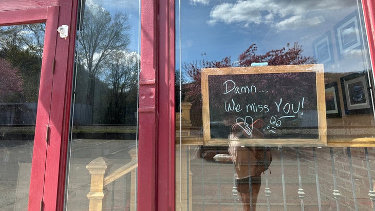
That is the spirit I encountered time and again in Hot Springs, a town I left two years before the floods but feels sacred to me, nevertheless. There was the library, tucked temporarily beneath a former Methodist church, and the artisanal grocery store and sandwich shop in a pine outpost next door. There was Vinyl Pies Pizza, where a construction crew worked on rebuilding inside until they lost their Saturday evening daylight. Spring Creek Tavern had left its Halloween decorations clinging to the building where its porch once stood, before the waters swept it away. “Damn…We miss you,” read a note in the window of the Iron Horse Station, where I’d inhaled a mountain of fries after that formative 2014 hike. Like so much of Hot Springs, that message felt like an act of resilience, a promise to come back.
When Covid-19 decimated the 2020 thru-hiking season, the worry was that potentially sick hikers could overrun a town like Hot Springs, where resources are low and hospitals are an hour away. That is not the worry now. Every business owner or employee I spoke to said some variation of the same thing, from the bartender at the recently reopened Big Pillow Brewing to Big Kat, a thru-hiker who is running the Appalachian Trail-er hostel this year: Send everyone, and tell them to bring their money. That’s what we need to continue rebuilding.
Sunday, April 6 (Northbound Mile 281.1–302.1)
There was little rush to get out of Hot Springs on this stormy Sunday morning; overnight, the wind whipped the rain so hard that Left Field, the one hiker who had opted to spend the night camped on my hostel’s porch, retreated inside just before sunrise. Indeed, one of the hardest lessons that first-time thru-hikers must learn, especially somewhere as perpetually moist as the AT, is when to forge through the rain and when to take a day off. Today, at the start of two days of expected downpours, almost everyone decided to take the latter option.
Not me: I was too eager to see how the trail functioned after an overnight deluge to sleep in, so I caught a ride to Tanyard Gap above Hot Springs just after 8 a.m. The AT is almost always rooty or rocky, uncountable footsteps during the last century having kicked away much of its topsoil. Helene inarguably made that worse, turning parts of the trail into a rushing little river and sweeping whatever dirt remained into gaps and creeks and streams. While moving uphill, as I did leaving Tanyard Gap bound for the Rich Mountain observation tower, that was barely a problem.
Dropping down into the aptly named Hurricane Gap, though, I proceeded with extra caution, grabbing the occasional rhododendron branch to balance myself on particularly onerous sets of roots and sometimes trying to find the edges of my Topo shoes like they were downhill skis, slowing my slide whenever I hit a mud patch. Someone had passed that way on horseback the night before, it seemed, the horse’s hooves exposing just how vulnerable the trail remains—each print resembled a crater, especially along the softest shoulders.
As with my march into Hot Springs, the trail itself was remarkably clear of debris, thanks to the Carolina Mountain Club’s recent efforts. Trees, though, don’t fall only during a storm; they fall for months or even years afterward, compromised roots finally giving way with time, wind, or rain. The volunteers hadn’t gotten to some new ones.
And that’s the real danger when the trail is wet—climbing over, under, or around fresh deadfall when going downhill on slippery ground. More than once, I grabbed a branch, clambered over a fallen tree, and simply let my feet give way until my rump met the dirt, almost like I was creeping down a slick snowfield without spikes. Given the way the AT winds around valleys and gaps in slow semicircles, one side often offers a long drop into the woods below. Avoiding those took a little forethought.
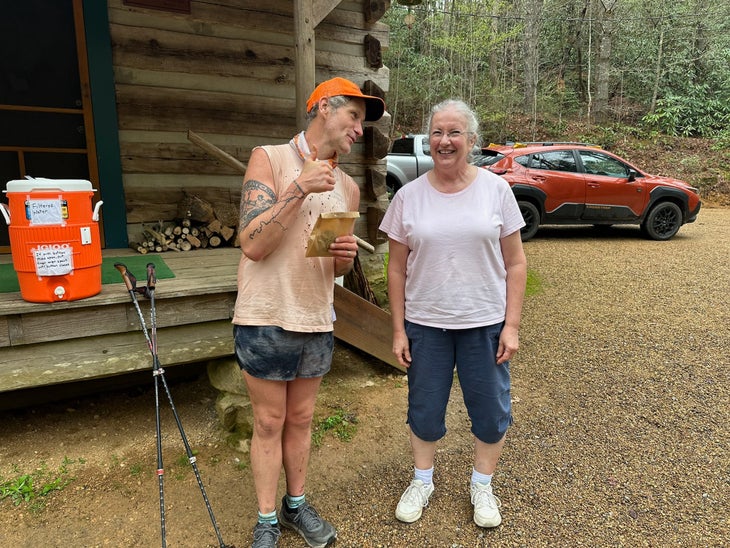
The folks who stayed in town made a mistake, though. After the overnight downpour, occasional showers drifted through the hills, keeping the trail skiddy but not making the day miserable. It was cloudy and cool, perfect for big miles into and over several steep gaps. Indeed, in one such gap, a neon pink paper sign pointed to the Southern Cookie Lady, a retired Ohioan named Peggy who settled into these woods three years ago. Most days, she sits on her porch and listens to hiker tales while serving up bagged apricot cookies and warm cobbler. The first cookie is free, but money from anything else goes to the Hot Springs Public Library, still in the process of rebuilding after losing thousands of volumes in the flood. Peggy only lost power and a few trees in Helene, but she was using the good fortune of her relatively calm quarters to help her community, tucking all donations into a Cool-Whip jar.
It wasn’t the only thing that reaffirmed the trail’s spirit for me today. With a new wave of storms expected overnight, I stopped at Jerry’s Cabin, a shelter perched in an idyllic clearing at 4,000 feet. In 2019, it was the first place my class of thru-hikers encountered Sovereign, a man who went on to stab a fellow hiker to death a few hundred miles up trail. I was feeling anxious until Thunder Lizard—a 25-year-old musician from Vermont who forages for ramen garnishes while he walks—began playing a few songs on his ukulele. He did some serviceable Dead and Vampire Weekend before playing “Dance Music,” by an old friend of mine called the Mountain Goats. It’s a song that’s kind of about the last tendrils of desperate hope in very desolate hours. Thunder Lizard’s shouted rendition felt a little like a hug and a lot like the kind of necessary magic the AT can deliver with suspicious regularity.
Monday, April 7 (Northbound Mile 302.1–327.7)
Today, a tree almost fell on top of me.
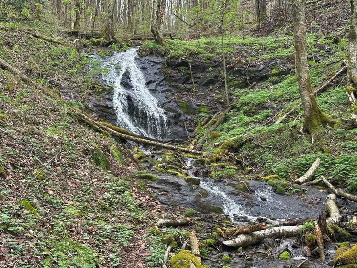
I was 10 miles into an aspirational trail marathon, my start slowed by torrents of rain that kept everyone in their sleeping bags until the hour started to feel absurd. I worried that I’d run out of daylight, and I had also run out of water. I climbed out of Devil’s Fork Gap—in spite of the name, an absurdly bucolic patch of farmland and forest on the North Carolina/Tennessee border—until I reached the last point where the trail crosses Sugarloaf Branch, just above its first little waterfall. I was dumping electrolytes into a bottle of perfectly cold water when the woods ruptured.
My first thought was that some wild animal was bounding through the branches. But as I scanned the brush, I watched a tree 20 feet away explode, its 20 feet of solid wood bursting into a half-dozen bits on contact with the earth. I had a little moment of gratitude for sitting here, not there, kept drinking and then continued climbing.
There is no real way to know, of course, if that tree had been damaged by Helene, hanging around through six months of limbo, just waiting to interrupt my water break. Trees fall, and blaming each one on the last big storm is like blaming every summer rain on climate change. But it did reinforce the vague feeling I had so many times during these 140 miles—that the woods were slightly more dangerous now, from the broken branches that snagged my bare calves to the extra patches of exposed roots that threatened my ankles. I made an extra note to check above my tent for any potential deadfall (always the right idea, anyway) and, in the meantime, to move swiftly, staying aware of big falling sticks.
That rain stuck around all day, bands shuttling across the ridges and into the gaps every hour or so. But I was heartened to see a group of a half-dozen hikers with daypacks, smiling as they climbed out of the gap while I descended into it. I wondered if perhaps AT guru Warren Doyle was around, leading them through a “smart hike” that allows beginners to knock out a chunk of trail efficiently. Doyle was fiercely critical of early efforts to keep people off the trail after Helene, insisting that reports of damage were overblown. (He was, I believe now, at least half-right.) I knew that Doyle himself would be near the trail come hell or, well, high water. But if others trusted trail conditions enough to join him, I thought it must be another sign that the trail was coming back online.
That’s not to say, of course, that everything was copacetic. I passed several spans where the sawdust of the Carolina Mountain Club was again fresh, relics of their work to bring some order to the chaos Helene had left behind. What’s more, I encountered a half-dozen dead trees in the span of a few miles that bore the AT’s signature white blaze, a 2-inch-by-6-inch strip of white paint. A hiker, it seemed, was carrying a Sharpie, maybe to turn roadside trash into hitchhiking signs every time they needed to get to town or graffiti their names onto shelter walls. On the blazes that belonged to those fallen trees, they’d drawn little frowns, black eyes peering up from the side of some wounded oak. The first time I saw it, I chuckled; I’m not ashamed to admit that, the sixth time I saw it, I got all verklempt.
I finished the marathon, rolling into Bald Mountain Shelter—at more than 5,000 feet, a relatively high one for the East Coast—just after 7 p.m. I’d crossed Big Bald, an exquisite bit of trail, in a cloud, the wind whipping against my headphones as I listened to Godspeed You! Black Emperor’s first album. Some bit of political news had inspired the choice, and I’d wanted to hear its spoken-word prologue: “The car’s on fire, and there’s no driver at the wheel … And a dark wind blows.”
It felt good to know, at least, that people were taking care of the Appalachian Trail, whether or not they were being paid to do so. As I fell asleep that night, I thought about how lucky I was to be there, nestled in bed alongside a half-dozen other hikers. It is the country’s trademark trail and, I think, still its best—a resource worth all the work.
Tuesday, April 8 (Northbound Mile 327.7–344.5)
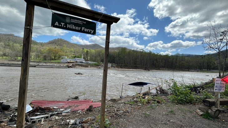
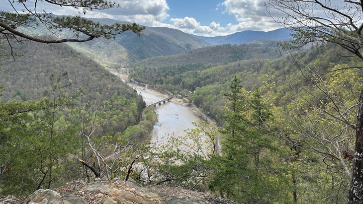
I began this 140-mile sprint with one very specific goal: to cross the Nolichucky River in Erwin, TN. During my first thru-hike, in 2019, my mother-in-law scooped me and my wife outside of Uncle Johnny’s, the legendary hostel along that wide river’s banks, for a funeral in Indiana. She dropped us off several days later on the bridge across the Nolichucky; that was the last time we’d see family for months, and I always saw it as a pivot point in our hike, the moment we cut the cord of possibility that we could just head home.
Helene decimated that bridge, sweeping it downriver in gargantuan slabs that are still stuck there like roadblocks. When people spoke of the potentially dashed chances for a 2025 hiking season, that was a point of consistent concern: How would hikers get across the river? There was the promise of a long road detour or the prospect of a dangerous railroad crossing. And then, as Uncle Johnny’s worked to rebuild, they hatched a plan alongside the Appalachian Trail Conservancy to run a ferry from the hostel to the other side of the river, operated by river guides out of work due to Helene’s aftermath. It’s how hikers in Maine cross the Kennebec River, anyway, so why not here?
But there was no boat to be found beneath the vinyl “A.T. Hiker Ferry” banner, its schedule disrupted for the day by a river that was raging a little too hard. When I asked Terry Wise, the long-distance hiker who bought Uncle Johnny’s in 2021, about the ferry, he vented about the U.S. Forest Service’s refusal to put the launch pad on their land, a parcel that offered a safer ride even on rough days. A cavalcade of dump trucks doing road repairs rolled by constantly, making it clear how perilous the road walk was. The best thing hikers could do, he thought, was wait until tomorrow.
But my trip was done, and my ride was waiting in the Uncle Johnny’s parking lot. As I moseyed toward an old friend’s car and, in turn, to a Bojangles biscuit, I realized there were worse fates for the AT hikers of 2025 than waiting for tomorrow. That morning, I’d passed through the most severely damaged sections of trail I’d encountered, half-mile spans in which the Carolina Mountain Club had cut hundreds of trees and forced the remnants just off the trail. It often felt like walking through endless cords of firewood, the gap between the logs barely wide enough to offer safe passage.
When I first saw the way the trail wove through those seemingly endless debris fields, especially above the deep drop of Spivey Gap, I thought of it as a miracle, an act of divine intervention. And then, of course, I realized that such an idea undermined the exhausting and dangerous work of the volunteers, like my old boss Mike, who had done what no government or god had bothered to do: save the 2025 AT season by putting their own lives on pause.
The feeling was reinforced several miles later at Temple Hill Gap, a relatively high slit in the ridge. In every direction, the trees were scattered like carcasses in a slasher film, covering nearly every square inch of the holler below. I had just left the jurisdiction of the Carolina Mountain Club, and I suddenly saw what Ron, that volunteer I’d met nearly a hundred miles earlier, meant when he said, “For every one tree left standing, you’ll see 20 that are down.”
Here was that scene of near-total devastation, where the woods were a little more than a jumble of matchsticks. I stood there for a long time, trying to remember that wonderful bit of forest as it had been in 2019 and trying to imagine it as it would become—debris at best, landslides and forest fires at worst. I was thankful for the present passage and anxious for what was to come. I turned and headed for Erwin and the Nolichucky, toward a river I would not be able to cross, at least not today.